Green City

Jahlil-krystal-james
THE PROBLEM STATEMENT: People not knowing there communities wells so this map will help them find local hot spots
(places with wifi, bicycle places, trash cans that are solar powered, etc)
BRIEF DESCRIPTION: It is a 3D map of the south end area complete with buildings and streets.
There will be a grid of LED lights underneath the mapped area screen-shot, they will light up where there is a location/ hotspot that is unknown to people.
It helps people know where locations and local hotspots are and so that they can be more aware of their surroundings.
TECHNOLOGIES AND MODULES:
Fab Lab: the design of the map
Arduino: the lights underneath the mapped area
Molding resin/ cans and bottles?: the buildings
MATERIALS:
http://www.scrollsawer.com/forum/beginner/1917.htm
http://www.objet.com/customer_support/ordering_resin_north_america/
Home depot
PROS AND CONS:
Cons
-may be difficult to change the buildings and the map if needed
-won't have all the street names to help lost people
-has to be plugged into a wall
Pros
-it shows you locations of hot spots
-it uses recycled materials to send a message
-it gives you some knowledge of your neiborhood
Questions & problems
will it be able to be updated when needed?
will we plug in wall or use batteries?
were will it be stationed?
progress report for July-12
goals for the day
-download google sketch
-work on google sketch
-build platform
progress report for July-13
goals for the day
- make a few prototype buildings
- save the laser cutter measurements on a flash drive
- continue Google sketch up
- draw up a plan of the case for the screen
- learn to use shop bot
progress report for July-14
goals for the day
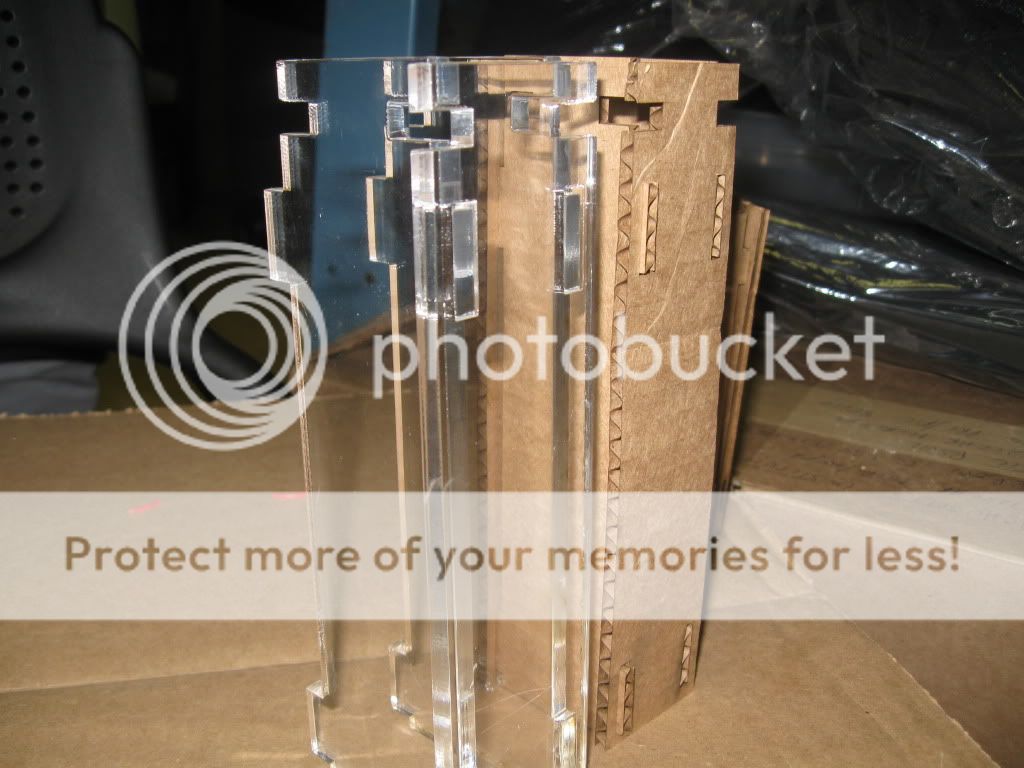
- continue model (hopefully finish) make out of acrylic
- get screen to work
- figure out what we're gonna do
Progress report for July-15
Goals for the day
-finish making the prototype using cardboard and acrylic material
-use scratch to show how we're going to show the map under the city
-get the screen to work
Progress report for July-21
Goals for the day
-Focus on getting the screen ready and making it work with the project
-finish make all the scaled down buildings out of acrylic
-use scratch to get the information for the screen
-make the screen covering
Progress report for July-22
-Complete scratch portion w/ scratch board
- do cardboard version of screen case save measurments for acrylic
- know what were using the buildings for
-
Video Links:
http://hypert.info/pics/mbta_map.gif
http://maps.google.com/maps?hl=en&um=1&ie=UTF-8&q=places+where+there+is+wifi+in+copley&fb=1&gl=us&hq=places+where+there+is+wifi+in+copley&hnear=Boston,+MA&view=text&ei=bqJFTKTpIIGdlgf0_cTwBA&sa=X&oi=local_group&ct=more-results&resnum=4&ved=0CCoQtQMwAw
http://www.youtube.com/watch?v=Y0Wp9CmSKFY
http://www.youtube.com/watch?v=RSynol0bQzE
http://www.youtube.com/watch?v=LSH19G_6Yeo&feature=related
http://www.youtube.com/watch?v=gsfH_cyXa1o


Comments (3)
Allison Bland said
at 9:54 am on Jul 8, 2010
Comments from group
3d google map?
Static? It should be changed over time - lights easily changed
bubble over it..
Legend..
Name: Green Streets
Come up with categories with things: wifi ,bikes, etc
Buildings as buttons..
Future Proof - slide google map satellite underneath
terrell said
at 10:31 am on Jul 15, 2010
wat will happend if the world bLoWS uP! HAHAH
Donna Parker said
at 10:07 am on Jul 19, 2010
Where will you be getting the data of where the hot spots are etc. could you include that info on your Wiki....looking forward to seeing your finished product...I can visualize these all around the city and businesses would (like coffee shops etc) could pay to be included as it would be good advertising for them.
You don't have permission to comment on this page.